
By Mike Forty, Project Officer.
Restoring connectivity in rivers
One of the big challenges we face in restoring freshwater ecosystems is re-connecting disjointed sections of streams which have been isolated by construction of in-stream structures. These structures can have profound effects on streams, acting as a barrier reducing, delaying, or altogether stopping fish or invertebrate movements, and disturbing geomorphological processes. This barrier effect is arguably greatest when rearing and spawning habitats of migratory fish are cut off.
These structures come in many forms (e.g. weirs, culverts, dams) and were mostly constructed during the industrial revolution to power mills or divert water courses around infrastructure. With regards to the former, many structures are now antiquated but their legacy remains interrupting ecosystem connectivity. Where possible connectivity is best restored by removing these structures, however, often there are reasons why a structure must remain in situ (e.g. heritage, aesthetics, infrastructure) and this is where fish passes come in.
Fish pass types
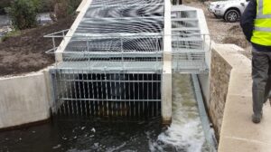
There are many types of fish pass that have been developed which can be grouped in to technical and nature-like passes. Technical types such as Larinier, Denil, and pool-weir traverse passes often use series of metal, plastic, or wooden baffles attached to the bottom/sides of a constructed channel to create very specific flow conditions to allow their target species to pass. Nature-like passes come in the form of constructed stream channels or rock ramps that are designed to mimic a natural stream channel, often creating a stream bed of boulders, cobbles and gravels. Nature-like passes are considered more aesthetically pleasing, but do require a lot more room for construction as they need to be built at a suitable gradient (≤ 5%) so velocities are not too great for fish to swim through.
After identifying a structure that requires a fish pass and discussing with structure/land owners we begin the design process by collecting site specific information on the river including what fish species are present. This is particularly important as different fish passes are suited to different species, as the mode of swimming and swimming ability in fishes varies greatly. For example, Atlantic salmon are very strong swimmers and leapers compared with European eel, as such they have different requirements in terms of fish passage.
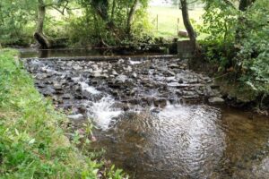
In-channel rock ramp built on flat sloping weir
While collecting this data, we will have a surveyor undertake a topographical survey for us which will give us detailed information on the dimensions of the structure, river channel, and banks. We can then use these drawings and data to evaluate which type of fish pass will be best suited to the situation using an options appraisal. The options appraisal evaluates each design option available against any mitigating factors from the list of design factors below, with the final design choice being that which correlates best with them.
Design factors
-Species target/present
-Existing known fish migration behaviour
-Size of Catchment
-Barrier Location Within Catchment
-Invasive Species
-Other Ecological Constraint
-Flooding
-Construction Constraints
-Access
-Health and Safety
-Services
– Wider stakeholder interests
-Aesthetics
-Historical heritage interest
-Adjacent Land use
-Short-term and long term objectives
-Maintenance
-Debris clearance
-Repairs
-Budget
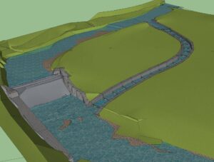
Artists impression of a natural by-pass channel
The design process
Our design work is conducted in Computer Aided Design (CAD) software that allows us to create detailed drawings of fish passes on top of topographical survey data. Depending on the type of pass we’re designing, we identify the best location for it from the data, looking to see if there are any elements of the environment that we can take advantage of to make construction easier. For example, a dried-up river channel might offer an ideal location for a nature-like by-pass. Then following guidance from the Environment Agency’s Fish Pass Manual (among others) we create the design drawings with cross-sections, long-sections, and in plan-view that detail the dimensions of the fish pass, what materials are used, and the construction process. In all circumstances these fish passes will be designed so as not to increase flood-risk and in most circumstances, need to be approved by the Environment Agency’s National Fish Pass Panel before construction can proceed.
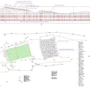
Example of a plan and long section of a low-cost baffle and rock ramp design