Slowing the Flow at Worston Brook
As extreme weather events become more frequent, managing flood risk is becoming increasingly important for communities across the Ribble catchment. Traditional flood defences, such as walls and embankments, aren’t always cost effective- and can sometimes simply move the problem downstream. This is where Natural Flood Management (NFM) steps up.
Using evidence to guide action
At Ribble Rivers Trust, data and evidence guides all our projects. By using GIS tools, we can identify the areas and interventions that will provide the greatest benefit. This isn’t just for flood management, but for water quality, wildlife, and people too.
This approach has already helped us deliver peat restoration, soil improvements, and woodland creation in the Mearley Brook catchment, tackling some of the upstream issues that contribute to flooding. But one thing has been missing: measures to slow the flow within the river channel itself.
That’s why, with support from local landowners including the Downham Estate, we’re now turning our attention to Worston Brook, a tributary of Mearley Brook.
What’s happening at Worston Brook?
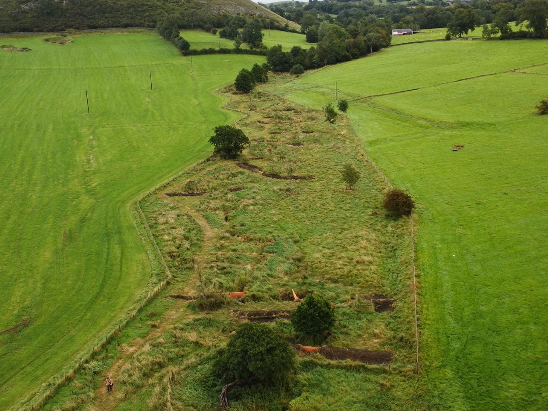
Our surveys showed that Worston Brook is largely lacking in natural woody material. This means important river features, like riffles and pools, are less common than they should be, reducing the habitat available for fish and invertebrates. By reintroducing structure to the channel, this work will improve biodiversity as well as flood resilience.
These features mimic the natural role of fallen wood in river- slowing the flow of water, helping sediment settle, and reconnecting the brook with its floodplain. By storing more water in the landscape, we can reduce the peak of flood events. In turn, this eases the pressure the watercourses downstream in Clitheroe.
Different techniques for different places
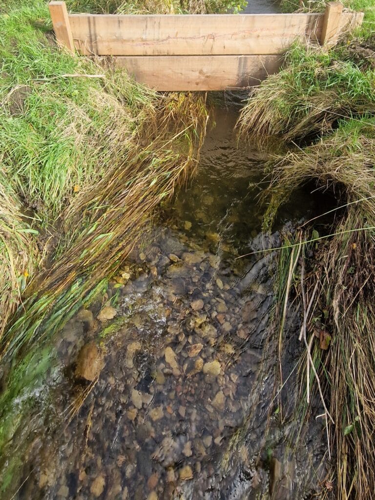
Around 85% of Worston Brook is a narrow channel (1–2 metres wide) with very little tree cover. Here, we’ll be using a leaky board design, which is ideal for small streams. We can also construct these from locally sourced materials.
The remaining 15% of the brook runs through woodland, with a slightly wider channel of 2–3 metres. In this section, we’ll use a wedged log design, where carefully positioned logs are anchored into surrounding trees. These structures are strong enough to withstand the force of both summer floods and winter high flows. Importantly, they sit well above the riverbed, so fish can still move freely.
Alongside these barriers, we’ll also be creating brash barriers and scrapes. These will extend into the floodplain, holding back even more water and increasing storage capacity during heavy rain.
Wider benefits for rivers, people, and wildlife
Humans aren’t the only ones who feel the effects of flooding. River dwellers such as invertebrates and fish are particularly vulnerable to high flows. Many migratory fish, including Atlantic salmon and sea trout, spawn over the winter months, and flooding can wash out the eggs and fry, wiping out entire generations of fish populations. Similarly, river invertebrates are adapted to fast flowing rivers, they too are easily carried away by high flows.
The benefits of these interventions don’t stop at flood risk reduction. By reconnecting Worston Brook with its floodplain, sediments and nutrients will be trapped on land rather than washed downstream. This helps improve water quality, reducing pressure on our rivers, and creating healthier river habitats for fish and invertebrates.
Importantly, this work also ties in with the support we’re providing to local farm groups around soil and nutrient management. Together, these actions add up to healthier rivers, more resilient communities, and better places for wildlife to thrive.
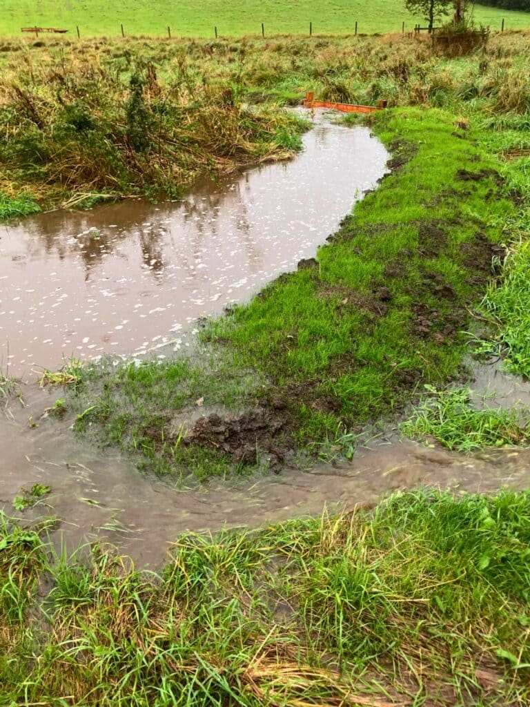
Heavy rains tests the Worston Brook works
So far this year we’ve had one significant period of heavy rain, and we’re delighted to see that the dams are holding back water and sending it onto the flood plains. Interestingly, they’ve also already had an effect on the geomorphology of the brook.
On this picture of the dams, you can see that the dam has increased flow speed underneath it, scouring out a deep pool in the bed of the river and depositing gravel downstream. This creates a pool-riffle sequence, which is a extremely important feature for fish habitat; the pool is great for fish to rest in, out of the way of predators, and the riffle is ideal spawning habitat. Luckily, this habitat is now available just in time for the start of the Atlantic salmon and brown trout breading season.
How will you measure the success of this project?
The Data and Evidence team have been gathering a wide range of in-depth datasets for this project. Unusually, this project allows us to gather data before, during, and after the project completion. To do this, we have used a wide variety of methods and tools, including camera traps and time lapse camera, flow monitors, sediment traps, depth gauges, wildlife surveys, fish surveys, and more. We will also be monitoring hydrogeomorphological changes over time by conducting regular modular river surveys (MoRPh surveys).
Excitingly, all our data will feed into a national database, and will help shape best practise across the whole of the UK.
Environment Agency Natural Flood Management programme
With funding from the Environment Agency’s Natural Flood Management programme, we’ll be installing a series of engineered logjams and leaky dams across several sites in the Ribble catchment, including at Worston. This £25 million fund has supported 36 similar projects, including two more of our projects; one on Darwen Moor and another at Wrea Green.

Rivers are at the heart of our local landscapes. Whether you’re casting a line, exploring a riverside trail, or simply basking in the beauty of nature, you can help protect these special places now, and for generations to come.
By becoming a Ribble Rivers Trust supporter for just £3 a month, you’ll be funding real, on-the-ground action.
Ready to make a difference? Learn more here: ribbletrust.org.uk/become-a-supporter